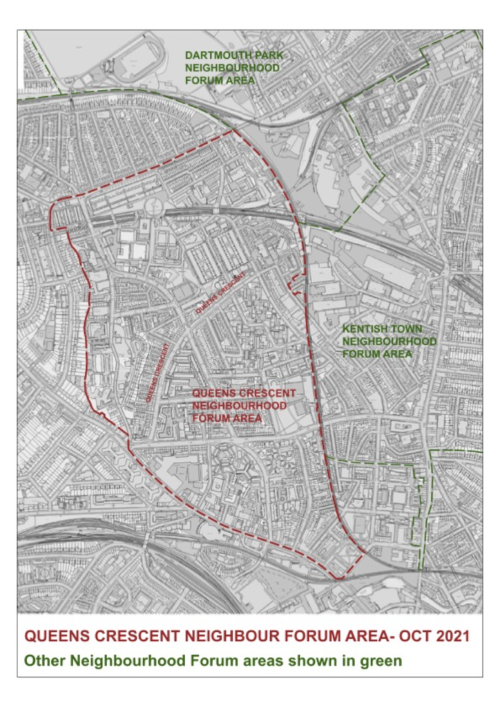
Queen’s Crescent is at the heart of a neighbourhood which has very hard boundaries in almost every direction. For inner London, they are unusually impermeable. People living outside these boundaries are unlikely to come into the neighbourhood for work, shopping, leisure or even to use travel nodes. Conversely, this gives the people who do live within the area a particularly high stake in its future development.
The neighbourhood boundaries:
To the south: Chalk Farm Road runs along the south boundary. The south side of the road still has much of the brickwork of the ‘great wall of Camden’ once the boundary of the goods yards and warehouses of the railways. Along the entire length of Chalk Farm Road there is no through route even for pedestrians. Between the road and the railway lines even further to the south lie Camden Lock Market, the Roundhouse and large new developments. All of these have an entirely different character from the buildings to the north of the road. The road itself is therefore a good boundary also recognized as being a divider between wards and the edge of a conservation area.
To the west: Haverstock Hill, until its junction with Prince of Wales Road, forms the bottom end of this boundary. There is a sharp distinction between the inter-war blocks to the boundary’s west, and Haverstock school, the single largest street frontage to the east. This secondary school is an important element in the neighbourhood’s identity. The west boundary turns up Maitland Park Road and then Southampton Road up to its junction with Malden Road, taking in the back lands of all the properties accessed from these roads. Along this entire boundary there is no through route even for pedestrians. It precisely follows the boundary line which divides the neighbourhood from the Park Hill conservation area to the west (with the exception of St Pancras Almshouses which are both within the neighbourhood and conservation area boundaries.) The exclusion of the neighbourhood forum area from the Conservation Area already recognizes its very different character. The neighbourhood boundary then continues up Southampton Road to its junction with Mansfield Road, with just one pedestrian route out (Alan Cheales Way).
To the north: The northern boundary is Mansfield Road. The north and south sides of this road were developed at different times and have very different characters. Waxham, with the claim to being the longest unbroken residential block in Europe, is part of the council estate to the south and takes up the majority of the frontage. Although there are two vehicle entries and a further pedestrian/cycle route into the neighbourhood area off Mansfield Road, due to road closures there is no through route for vehicles. The original late Victorian development to the north of Mansfield Road has survived pretty much intact with terraces of large street houses. Its designation as a conservation area recognizes its separate and homogenous character. To the north of this grouping of streets is Hampstead Heath an even sharper delineator. Although the housing is of a very different character from anything inside the proposed neighbourhood boundary, if residents in these streets did see an identity of interest with the neighbourhood it would be possible to include them.
To the east: The railway line from Gospel Oak until it crosses Castlehaven Road would be the eastern boundary. This respects the boundary of the Dartmouth Park neighbourhood and recognizes the very different characters either side of the railway tracks. At the northern end, inside the boundary there is the city farm and housing estates, outside is the Murphy’s yard site, and industrial estate and council depot. Further south there is Talacre Town Green inside, with a Victorian residential street pattern the other. At the bottom end the neighbourhood takes in the streets fronting Chalk Farm Road as they have an identity of interest with those further north. Not being part of the Kentish Town neighbourhood, they might otherwise become a curiously unrepresented island.
Generally: The boundaries of the neighbourhood forum address a contradiction. The area is at the very geographical heart of the borough. Camden has twenty wards. Only 3 do not share a boundary with another borough – and this proposed neighbourhood is made up of large portions of two of those three central wards. Yet with the hard boundaries described here, much of the borough’s social, cultural and economic activity flows round the area not through it. This is compounded by the fact that none of the borough’s 28 underground and overground stations are within the neighbourhood, with 5 spread around its periphery.
For those within the area, it is hard to answer the question: what neighbourhood do you live in? It’s not Chalk Farm, or Belsize Park or Hampstead or Kentish Town and for many it isn’t even Gospel Oak. Naming the neighbourhood Queen’s Crescent is a place most residents can identify with. It is the neighbourhood’s central spine with the focus of shops, a market, library, GP and more.